| Lithologic Sample Wells | Extraction Procedure | Original Database Format | Las Format | Lithologic Log Display |
| Figure temporarily removed |
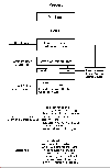 |
Figure temporarily removed | Figure temporarily removed | Figure temporarily removed |
A subroutine converts the character depths to integer values. For example, in the samples below it can be seen that for the depth range 605 to 665 the lithology is shale (SH) and for 845 to 875 it is gypsum (GY). This process creates a log "curve" file where the "curve" represents the lithology.
The next step is to convert the LAS file to the
Log Binary Standard (LBS) format. This is easily done by applying
GeoGraphix-Schlumberger QLA 2 Log Interpretation Program's
log conversion utility. QLA 2's Log Display
module is used to create the pseudolog lithology display template.
The figure titled Lithologic Log Display with Gamma Ray and
Neutron Density Curves shows the lithology "curve"
(with the curve area filled in with a color and/or pattern depending
on the lithology), gamma ray, and neutron density curves as well
as the top subsea picks for several formations. These log display
templates are used in conjunction with GeoGraphix Exploration
System's Cross Section and Wellbase modules
to create the pseudolog lithologic cross-sections seen on the
other section of this display.
The cross-section titled Stratigraphic Sequences
consists of four wells, starting in Missaukee County and running
through Clare and Gladwin Counties to Bay County. (See Plan
View Map of Michigan for the cross-section location, labeled
A-A'.) It is hung on the top of the Traverse Formation which contains
a highly radioactive layer, providing a good time line. The cross-section
consists of the lithology log "curve" and the top picks
for several formations. The top picks were used to determine the
location of the Sloss sequence boundaries3
(magenta lines).
The lithology log "curve" was employed to create the
relative sea level curves. These curves were drawn showing relative
sea level changes based on the solubility of the carbonates and
evaporites present in the basin (least to most soluble: limestone-dolomite-gypsum-anhydrite-halite).
High relative sea levels were associated with deposition of limestone,
the low levels with halite deposition. Where halite is overlying
limestone a rapid sea level fall was assumed. These relative sea
level lows were then correlated between wells, creating the 3rd
or higher order sequence boundaries (dark
green &
dark red
lines). Previous work done in the basin4
has recognized the existence of two of these sequence boundaries
in the lower Silurian: one at the top of the Clinton Group and
the other at the top of the Niagara Group. The sequence boundaries
in the cross-section below labeled 1
and 2
match those boundaries. The visualization utility of the lithologic
logs greatly facilitated the identification of these sequence
boundaries.
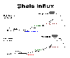
The cartoon titled Shale Influx shows the
probable mechanisms of shale deposition in the basin. The cross-section
reveals several episodes of shale influx. The shale layers surrounded
by halite are assumed to be deposited at relative sea level lows
(bottom section of cartoon). Conversely, those associated with
limestone are assumed to be deposited during relative sea level
highs (top section of cartoon).
Stratigraphic Sequences
Plan View Map of Michigan
Shale Influx
Figure temporarily removed
Figure temporarily removed