~click here to return to Well Log Tomography home page~
Well Log Tomography and 3D-Imaging of Core and Log
Curve Amplitudes in a Niagaran Reef, Belle River Mills Field, St. Clair
County, Michigan, U.S.
Animations and additional content (ref AAPG
Bull., v. 89, No. 4, p. 329-357, April 2005) [certain pages for
this website are still under construction as of April 3, 2005, please contact
the authors with questions] Albert S. Wylie, Jr. and James R. Wood Department of
Geological Engineering and Sciences, Email: aswylie@mtu.edu
or jrw@mtu.edu |
|
|
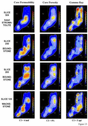
Figure 13. Comparison of four bottom-up core permeability, core porosity, and gamma ray slices from the wackestone, boundstone and basal stromatolite in the Belle River Mills Field (refer to Figure 6 for approximate slice locations). Note the permeability and porosity amplitude trends are approximately equivalent to the trends observed in the gamma ray amplitudes. This is an important observation and is significant in that it means that the log curve amplitude slicing of the gamma ray curves only may be able to be used to visualize the approximate distribution of permeability and porosity in reefs without core data (most Niagara reef wells have at least a gamma ray log curve) by utilizing the data from this benchmark reef. The permeability slice data range is 0 to 30 millidarcies with values greater than 30 md reset to 30. The contour interval for each slice is 4 millidarcies. The porosity slice data range is 0 to 36 percent. The contour interval for each slice is 4%. The data range for each gamma ray slice is 0 to 40 api units. The contour interval is 5 api units. All wells in the field have gamma ray curves through the reef. Gray lines are section boundaries and gray numbers are section numbers. North is toward the top of the slices. Large white dots are data control points on each slice and small white dots are other well penetrations. Slice numbers or elevation in feet above the reef base is displayed in yellow below the vertical scale bar. |
ABSTRACTWell log tomography, a recently developed technique that generates subhorizontal slices through log curves, was used to create a series of amplitude slices from the core permeability, core porosity and gamma ray log curves for the wells penetrating the Silurian Brown Niagara reservoir in the Bell River Mills Field. Log curve amplitude slicing and 3D-imaging of the core permeability and core porosity amplitudes show the detailed anatomy of the pinnacle reef in terms of these important reservoir properties. Although the reef has been dolomitized, the spatial distribution of permeability and porosity amplitudes in the reservoir appears to be controlled by the original pore and depositional fabrics of the wackestone, boundstone, stromatolite and reef conglomerate rock types. Trends and patterns observed in the normalized gamma ray log tomography approximate the trends and patterns observed in the core permeability and core porosity tomography in the Belle River Mills Field. The similarities in the tomography trends and patterns establishes a potentially significant relationship that can be used to interpret log curve amplitude patterns in other Niagaran pinnacle reef fields with log curve data only and perhaps lead to improved sequence stratigraphic models for these reservoirs. Well log tomography and 3D-imaging provide complementary visualization tools that use existing data to image reservoirs and geologic formations. These imaging tools can be used to improve the design and placement of vertical, deviated and horizontal wellbores for primary, secondary, tertiary, and gas storage operations in these reefs and other reservoirs. AcknowledgementsWe thank Carol Asiala for the
visual basic programming and figure preparation. We thank the reviewers Paul A. Daniels,
Paul A. Catacosinos and an anonymous reviewer for their helpful comments that
resulted in the final manuscript. We thank Anne Hartingh
for helpful reviews of the manuscript.
IHS Energy Log Services provided digital well logs. Neuralog Corporation provided the log
scanning and digitizing software. LandMark Corporation provided the GeoGraphix mapping and cross section software and RockWare provided the Rockworks2002 visualization
software through their respective University Grant and Academic Licensing
Programs. Parts of this research were
supported by DOE contracts DE-AC26-98BC15100, DE-FC26-00BC15122, and
DE-FC22-93BC14983, and DE-FC26-02NT15441 (PUMPIII) awarded to J. R. Wood at Link for information on Natural Gas Storage in these Reefs from the Michigan Public Utilities Commission Website. http://www.cis.state.mi.us/mpsc/gas/about3.htm |