Rift Background Info
 

Any individual place on Earth exhibits only tiny windows of Earth history. In the Keweenaw and Isle Royale, we can see into events that range from about 1.2 billion years ago until perhaps about 0.9 billion (Davis and Paces, 1990), and we can also see the deposits of the glacial periods of the last few million years.  To see the record of other times we must travel to where we can see rocks of those ages are at the surface.


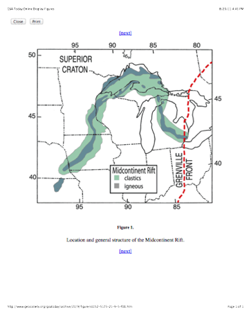
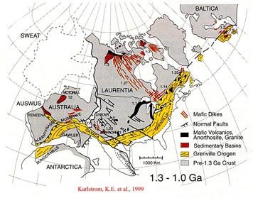
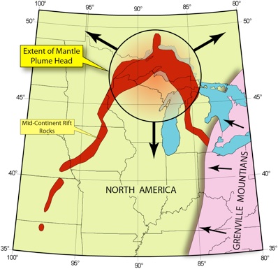
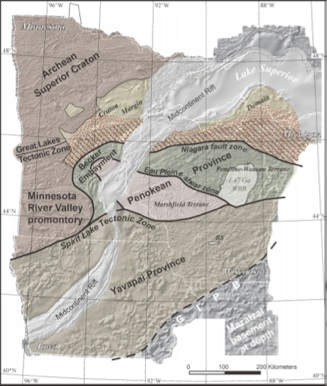
This is the very best place to see the exposed rocks of the midcontinent rift (left). This rift extended from at least Kansas to Detroit, but it is exposed only near Lake Superior. At the time of rifting there were huge differences in the configuration of the continents and a huge supercontinent, Rodinia, was assembled, a hodgepodge of pieces of what is now North America, Antarctica, Europe and South America.  And it was beginning to break up.


In the Keweenaw we get a remarkable opportunity to look at rocks produced during the rifting period of Rodinia, which preceded the orogens shown in green in Figure 5. The orogens mark the areas where continental blocks approached each other at about 1.1 by ago. The orogeny in eastern North America, which eventually ended the Keweenaw Rifting episode, produced an orogen known as the Grenville Front. (Cannon, 1994).

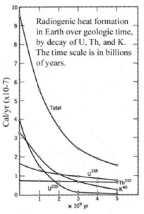
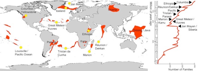
Rodinia’s assembly acted like a great blanket for a large area of Earth’s surface, preventing heat loss and creating an opportunity for heat to build up underneath. A great hot spot formed under the blanket. The continent began to split with very hot dike swarms.  When the splitting opened the rift, magma was erupted in huge amounts—a supereruption. The ancient Earth contained more radioactive heat producers so the potential for big eruptions was greater. We still think that most of Earth’s heat comes from radioactivity, and we still expect Large Igneous Provinces (LIPs) to develop when and where mantle hot spots occur.  But perhaps LIPs are getting smaller as time passes and natural radioactivity declines.

Heat flow on earth is declining with time as natural radioactivity continues to be spent.

Jessop & Lewis 1978

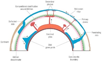
Convection of earth’s core and mantle do not produce steady heat transfer from earth’s core to the surface.

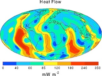
Since volcanism is driven by higher than average heat flow, volcanism comes and goes as heat flow changes in time and place. Overall, heat declines, but in any time or place, it can vary markedly in both directions. Super-eruptions result from very high heat flow conditions.


There is a huge fundamental earth scientific debate about the origin of heat flow, hot spot volcanism and related phenomena: Plumes vs Plates.


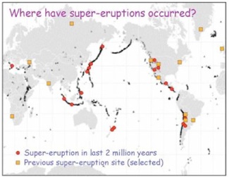
It is also possible to look at the geologic record of large eruptions--a recent study of this was made by Mason et al 04.

Geological Record of Supereruptions   

Large Igneous Provinces

     To explain the distributions of LIPs in time and place, volcanologists refer to plates, hotspots and/or mantle plumes, much of which which are far from our direct access. These plates, hotspots and plumes come and go, plates move over hotspots and/or plumes, and time/space series patterns are not clearly defined or forecastable. This requires volcanologists to consider the deep thermal origin of volcanism, which is fundamental geophysics of the deep earth and especially the mantle and core. For obscure causes, deep earth heat transfer leads to massive volcanism at rare intervals and in widely scattered surficial locations.  The surface manifestations may be huge volumes of volcanic rocks. The environmental consequences must be large, but are mostly uncertain. From the recent record of LIPs, a relationship of the timing of LIPs with extinctions of living species is advanced.

Volcanologists agree that super-eruptions lie in the earth’s future, but the time and place is uncertain.

Heat flow bottom line:

The Keweenaw Rift record shows how the earth has highly irregular deep seated convective events that help shape the planet.  They come and go in time and space.  Once the hot spot of the whole world, now the Keweenaw has heat flow that is far below average.

Local Rock Formations:

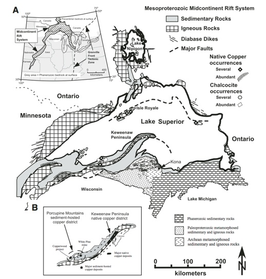
The diagram at right, from Bornhorst & Barron (2011), shows this mid-Proterozoic Keweenawan Supergroup, which contains all the formations of the rift.  These consist of lavas from the deep earth and redbed sediments, shed off of the top of Rodinia into the gaping rift.

On Isle Royale, we find only the Portage Lake Volcanics and the Copper Harbor Conglomerate, while on the Keweenaw we have all the others.


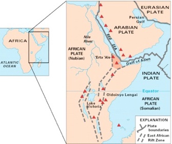
The USGS map above shows the East African rift zone and the Red Sea.  These are areas where rifting is occurring now.  In these places there are many black basaltic lava flows accumulating within rift basins, and there are also broad alluvial fans filling the basins from the steep flanks.

The Lavas of the Portage Lake Lava Series are the result of a continental Rift, very much like the currently active Red Sea. Existence of a rift is a way to explain how such huge volumes of lava could have been erupted. It also helps explain the syncline we already proposed. A great crack across North America formed, stretching from Kansas to the UP and then on to Detroit.

The map below shows the western limb of a feature called the “mid-continent gravity high” a linear feature that extends from Kansas to Lake Superior where it coincides with the Lake Superior Syncline.  This feature is mostly completely invisible, but was detected by geophysicists working with gravity meters, who showed that the gravity attraction of earth to the instrument is measurably higher, indicating dense rock underneath. The map shown here has that buried dense rock region colored green. The dense rock could be the dense black lava flows we have in the Keweenaw, and their gravity shows that the rift was hundreds of miles long.  Drill holes have penetrated the lavas in Kansas and Iowa, so we know that lavas are there--it is not just gravity detection.

A second geophysical anomaly, this one even more deeply buried, has been discovered extending from Lake Superior southward to near Toledo Ohio.  This adds to the definition of the hypothesized Keweenaw rift, which is sometimes described as a continental scale fissure, which resembles what happened in the Atlantic to separate Europe from North America.

Stein et al, 2011 GSA Today

The idea of a syncline comes from observed features in geology. In the Keweenaw we cannot see the whole syncline--far from it!  We just see the rocks dipping toward the North at Copper Harbor and those dipping to the South on Isle Royale.  In between is how geologists earn their money!

Implications of this Hypothesis:  1. Layers of rock extended from the Keweenaw to Isle Royale, apparently filling a basin.  2. Something caused the basin to subside.  3. The basin has influenced the formation of Lake Superior.  4. The basin may continue beyond the lake.  5.  Its importance could extend much farther than explaining the tilting.

K Schulz, USGS

K Schulz, USGS

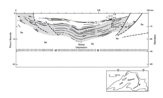
Profile across eastern Lake Superior, confirming the rift geometry with seismic geophysics (Modified from Behrendt et al. (1988).

NK Huber