| Blue Ridge Esker |
|||||||
|
Connection to the Earth Science Curriculum Essential Lessons: The Blue Ridge Gravel Pit provides an opportunity for visitors to discover two interesting stories that involve orange-brown boulders or fragments of sandstone found that tell of times when the climatic conditions were vastly different in Michigan than they are today.
Ammonite: An extinct marine cephalopod with a complex coiled partitioned shell that are related to octopus, squid, and cuttlefish. A
modern relative is the chambered nautilus. Carboniferous Period: A geologic division of the Paleozoic Era that followed the Devonian and preceded the Permian Periods. The Carboniferous is divided into a lower and upper unit known as the Mississippian Period and Pennsylvanian Period within the United States. Cartilaginous Fish: A fish whose skeleton consists mainly of cartilage and are most closely related to sharks, skates, and rays. Cementation: The process of binding sediments or grains together to make sedimentary rocks. Coiled Cephalopod: Marine mollusks that belong to the class
Cephalopoda that have a coiled shell that is divided into partitions. Coiled cephalopods have a simple shell
compared to ammonites. Crinoid: A group of animals known as echinoderms or sea-lilies that
are characterized by their cup-shaped bodies, feathery arms, and a stalk-like
structure that enables them attach to a surface. Cross-Bedding: Layers of sediment within a rock unit that do not run parallel to horizon. Cross-bedded sediments often appear to be tilted.
Gastropods: A class of Mollusks commonly known as snails. Snails are different from cephalopods in that
their spiral shells form without partitions or chambers. Gastropods may live in marine, freshwater, or
terrestrial environments. Glacial Till: Unconsolidated, heterogeneous mixture of clay,
sand, pebbles, cobbles, and boulders deposited onto the landscape by retreating
glaciers. Gondwanaland: A landmass that was located in the Southern Hemisphere that eventually broke up into India, Australia, Antarctica, Africa, and South America during the Mesozoic. Igneous Rock: A class of rock formed by the solidification of molten magma. Examples of igneous rocks include granite, pumice, basalt, and obsidian. Index Fossil: The fossilized remains of an organism that is used to identify or date the rock or rock layer in which it is found. Index fossils are often plants and animals that lived for a short period of time and had a wide geographic distribution. Kettle Lakes: Are shallow, sediment-filled
body of water that have formed by blocks of ice that have broke off from a
retreating glacier. Laurentide Ice Sheet: A massive sheet of ice sheet that covered most of Canada and a large portion of the northern United States between 95,000 and 20,000 years ago. Metamorphic Rocks: are pre-existing rocks that have been subjected to varying amounts of heat and/or pressure so that the grain structure within the rock is permanently altered. Examples of metamorphic rocks include gneiss, schist, marble, quartzite, and slate Mississippian Period: The Mississippian Period is the earliest
or lowermost of two time units known as Carboniferous. Nautiloid Cephalopods: Cephalopods that had straight or slightly coiled cone-shaped shells that were partitioned into chambers. Living relatives of the nautiloid cephalopod are the squid, octopus, and cuttlefish. Outwash Plain: Sediment deposited by melting water onto the
landscape in front of a glacier. Paleozoic Era:
A broad unit of time that represents early multi-cellular life on Earth
from 543 million years ago to 248 million years ago when 90% of all plant and
animal species became extinct. The six
geologic time periods from oldest to youngest they
are: the Cambrian, Ordovician, Silurian, Devonian, Carboniferous, and the
Permian. Pelecypod: Marine or freshwater mollusks having a soft body enclosed by two shells that are hinged together. Many people refer to this group of mollusks as “clams.” Pleistocene Epoch: A small unit of time within the Cenozoic Era that encompasses the most recent glacial advances on our planet between 11,700 and 2.58 million years ago.
Rock Cycle: A fundamental concept in geology that describes how sedimentary, metamorphic and igneous are able reclassified as they are eroded, transported, altered, or re-melted over time. Sedimentary Rocks: A class of rocks that are formed by the cementation of weathered sediments from preexisting rocks, precipitation from dissolved minerals, or through the accumulation of organic particles. Examples of sedimentary rocks include limestone, shale, sandstone, and conglomerate. Wisconsinan Advance: The most recent period of continental glaciation in the northern hemisphere that occurred between 10,000 to 70,000 years ago. The height of the Wisconsinan Advance occurred nearly 20,000 years ago when glaciers made their furthest advance toward the equator. Date
Visited July 14, 2011 |
The Blue Ridge Esker provides an opportunity to discover two interesting stories that can be told that involve orange-brown sandstone boulders or fragments found within it. These boulders tell a story of when climatic conditions were vastly different than what they are today in Michigan. Materials Needed for
Visit Permission from the Jackson County Road Commission, the
information provided, magnifying lens, rock hammer, safety goggles, and a
sketchpad or camera. Description:
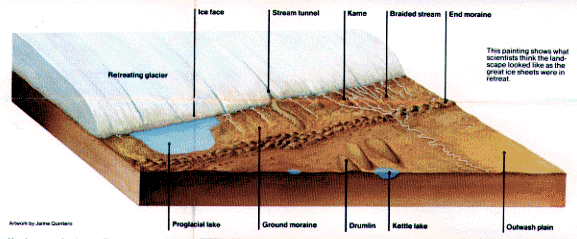
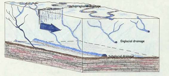
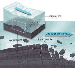
An esker is a “stream-tunnel” within a mass of ice that deposits a tubular structure onto the landscape as a glacier retreats (Figures 1 and 2).
Figure
Figure
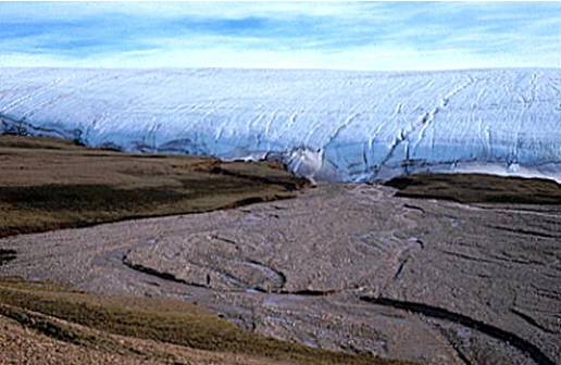
As a continental glacier retreats, sediments consisting of rock, gravel, sand, and silt are deposited as “outwash plain” in front of the glacier (Figure 3). The size and types of sediment that can be carried by a melt-water stream is largely determined by its velocity and volume.
Figure Streams or melt-water sources carry sediments in three different ways. Dissolved and suspended material is carried downstream within the water column whereas the heavier particles are able to skip or roll along the bottom of a flowing body of water. In other words, large boulders and stones require greater energies to be able to move them when compared to small sediment such as silt or sand.
Today, perched or winding ridges (Figure 4.) that appear of a glacial origin are called eskers and are considered to be valuable resources to a region. These rich deposits of sand, gravel, and rock are often mined by businesses or governmental agencies because they support a variety of construction needs including the creation and maintenance of roads and highways.
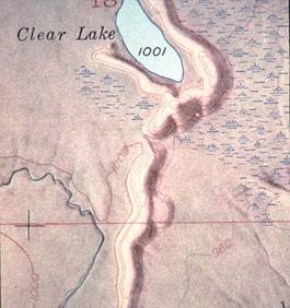
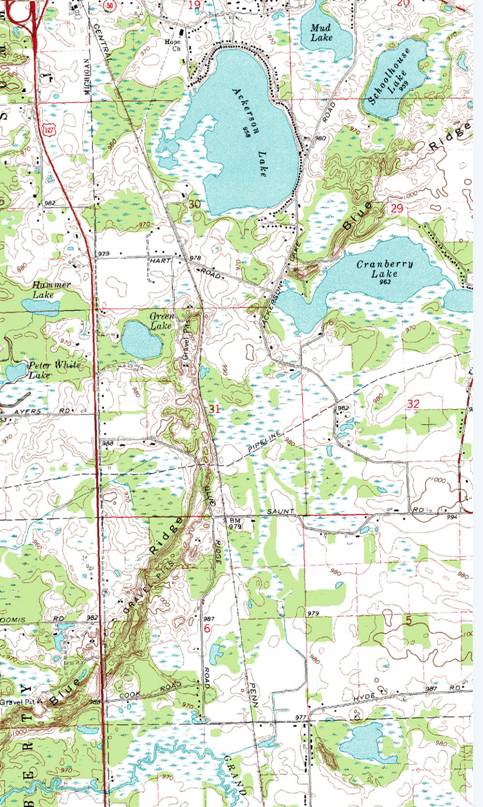
Figure The Blue Ridge Esker is often recognized nationally by Geology students and professors as a classic esker and glacial outwash plain. Maps such as the topographic map shown in Figure 5 have been used to teach Geology students how to recognize different landforms and their origins associated with continental glaciations. The Blue Ridge Esker appears on the map as a narrow brown feature with contour lines that are in close proximity to each other. Swampy areas on the map provide clues in regard to glacial outwash and blocks of ice that had once broke off the body of the main glacier have created numerous kettle lakes and ponds in the area.
Figure 5: Blue
Ridge Esker – Jackson Country, Michigan.
USGS Topographic Map
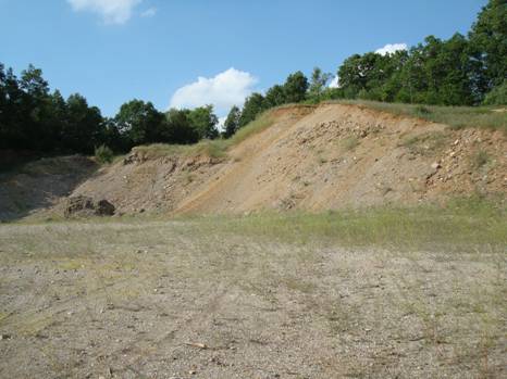
Figure 6: The
North-Northeast Cut of the Blue Ridge Gravel Pit - July 2011. Photograph by Mark S. Reed
Part 1:
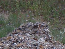
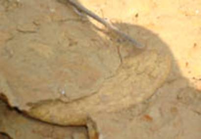
Figure 7:
“Clinker” or Cemented Rocks and Sediment. Photograph by Mark S. Reed However to a Geologist, the “clinker” material held together by dissolved mineral “glue” has created a unique but temporary structure that illustrates numerous Sedimentary concepts from the Rock Cycle. These concepts relate specifically to the origin, transport, sorting, deposition, and the cementation of sediments.
Question 1: This structure should be observed from at least 15 feet away since it has the very real potential to collapse as the cemented particles are weakened by the elements, vibration, and human activity. Sketch or photograph this structure and describe the types
and sizes of the sediments within it. What classes (Igneous, Metamorphic, and
Sedimentary) or types of rocks (Sandstone, Granite, Limestone, Schist, etc) are
present? How what specific ways do the types, sizes, and appearance of the
various types of sediments relate to the Rock Cycle?
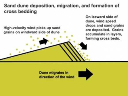
As the melt-water flowed through the ice tunnel known as the Esker, both coarse to fine sediment would be deposited as the velocity of the water varied. Glaciers also advance and retreat over a landscape as temperatures rise or fall. This in turn also changes the relative volume of melt-water, the velocity of the water, and the sediment load that can be carried prior to being deposited as outwash or glacial till onto the landscape. In most cases, sediments typically are deposited in a horizontal manner. This concept is known as the Principal of Original Horizontality. This suggests that if a tilted sequence of sedimentary rocks is found, it is likely that a geologic process has altered the orientation of the rock from when it originated. However, it should be noted that cross-bedded sediments appear to be tilted due to their depositional history. Cross-bedding occurs when particles are eroded by wind or water and begin to pile up creating a sloped structure as shown in Figure 8. If the wind or water has enough velocity, particles will be carried up the crest and tumble downward to the bottom of the lee slope where it can be re-deposited. As the water or wind flow continues, the slope will migrate in the direction of the flow and erode material that had previously had been deposited at the bottom of the lee slope. This erosion and re-deposition pattern creates a sedimentary structure that looks different. Geologists can use cross-bedded sediments to determine both the direction and the velocity of the air or water involved.
Figure 8: Tilted Sequence of Rock Known as Cross-Bedded
Sediments are Formed when Erosion Agents such as Wind
and Water are able to Erode, Transport, and Deposit Sediment along a
Slope.
Question 2: This structure should be observed from at least 10 feet away since it has the very real potential to collapse as the cemented particles are weakened by the elements, vibration, and human activity. Sketch or photograph this structure and describe the types
and sizes of the sediments within it.
Using your GPS, what was the direction of the flow?
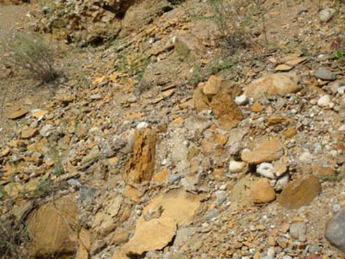
The Blue Ridge Esker has yet another story to tell beyond its glacial roots. The main storyline of this exercise will examine the Orange-Brown Sandstone boulders and related plate-like fragments (Figure 9.) that are easily found along the floor or at the base of any slope within the Blue Ridge Gravel Pit.
Figure 9: Orange-brown Sandstone
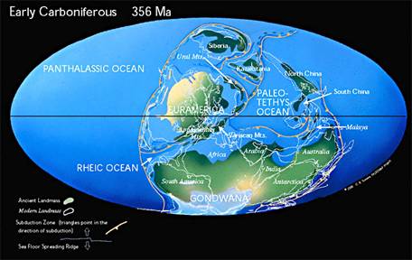
Boulders and Fragments of the Marshall Formation. Photograph by Mark S. Reed. The orange-brown sandstone boulders have at least two stories that can be read from the rocks. The first tells about the environmental conditions and fauna of the Mississippian Period when Michigan lay near the equator (Figures 10.) and was covered with a vast inland sea about 330 million years ago known as the Michigan Basin (Figure 11).
Figure 10:
Earth during the Mississippian Period.
Copyright by Christoper R. Scotese.
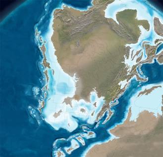
Figure
11: North America during the
Mississippian Period. Please note that
Michigan was covered with a shallow, warm sea that was rich with marine
life. Copyright by Ron Blakey of
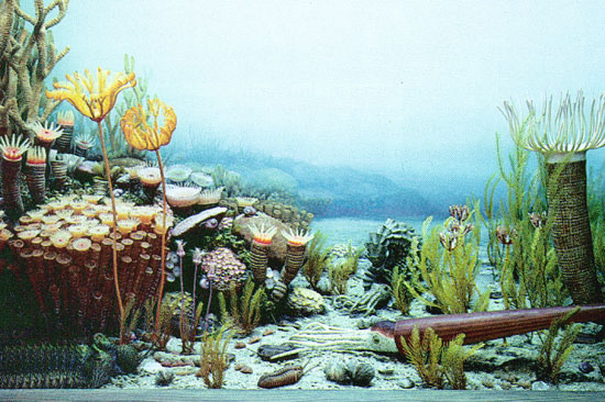
Colorado Plateau Geosystems, Inc. Among the animals present in this Mississippian Sea were cartilaginous fish or sharks, nautiloid and semi-coiled cephalopods, pelecypods (clams), ammonites, gastropods (snails), crinoids, trilobites, brachiopods, and a variety of types of coral (Figures 12 and 13). Geologists often use fossils to help establish the age of a rock formation that are known as Index Fossils. Since cephalopods and ammonites have unique physical characteristics, lived over a short geologic time, and had a wide geographic distribution, they make excellent index fossils. The wide geographic distribution of cephalopods and ammonites relates to the fact that they were sea-dwellers and could thrive within a large geographical area. Secondly, when cephalopods and ammonites die, their shelly remains may have enough buoyancy to be carried by waves and currents until such a time that they might wash up onto a beach and/or be buried in the sand. Despite the fact that fossils can easily be found in many sedimentary rocks, the process of fossilization is relatively rare. In general terms, animals or plants with hard parts that have been buried quickly or have died in environments without abundant oxygen or scavengers have the best chance of becoming preserved as fossils. Exceptions to this rule can be found in nature but are extremely rare and often relate to the burial or encapsulation of a life-form in a very fine sediment or substance that represent a low-energy environment.
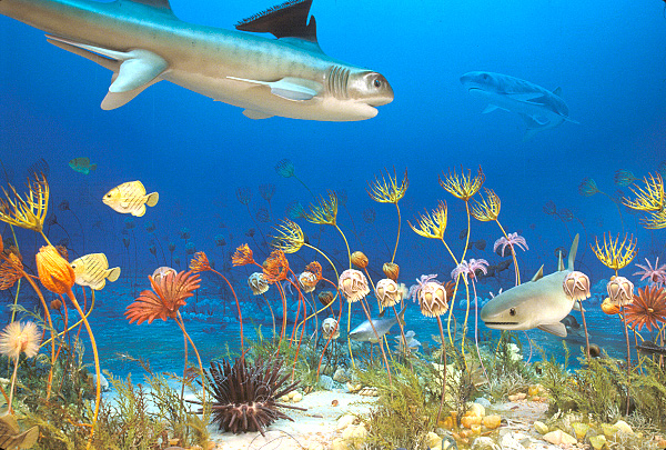
Figure 12:
Cartilaginous Fish and Crinoids of the Mississippian.
Figure 13: Life
at the Bottom of a Paleozoic Coral Reef If a time-traveler had the ability to transport himself back in time to the Mississippian, he would probably enjoy walking along the beaches of the Michigan Basin with his toes in the warm salty-surf. Here he would likely see whole shells and fragments that tumble as the waves lap up on the beach. Other shell fragments could be seen already washed up on the beach while others could be discovered by digging into the sand. Such a trip might invoke thoughts of visiting a tropical beach today minus the influence of man. If our time traveler visited this beach today, he would discover that the sand has lithified to form a layer of rock that is known by geologists as the Marshall Sandstone. The whole shells and fragments in the Marshall Sandstone help scientists known as Paleontologists examine the life that was present during the Mississippian Period. A popular misconception that many people have is that fossils found in Michigan are of animals that lived when dinosaurs ruled the Earth. The fossils from the Marshall Sandstone were deposited at least 100 million years before the first dinosaurs and nearly 265 million years prior to when the last dinosaurs became extinct at the end of the Cretaceous Period. Fossils from the Marshall Sandstone can be identified by using classic resources such as Geology of Michigan by John Dorr and Donald Eschman in addition to the published papers by A.K. Miller and H.F. Garner. Miller and Garner studied various types of cephalopods and ammonites from the Lower Mississippian Period like the one shown in Figure 14 in the 1950’s.
Figure 14: A common Ammonite of the Marshall Sandstone. - Merocanites houghtoni. Photograph by Mark S. Reed
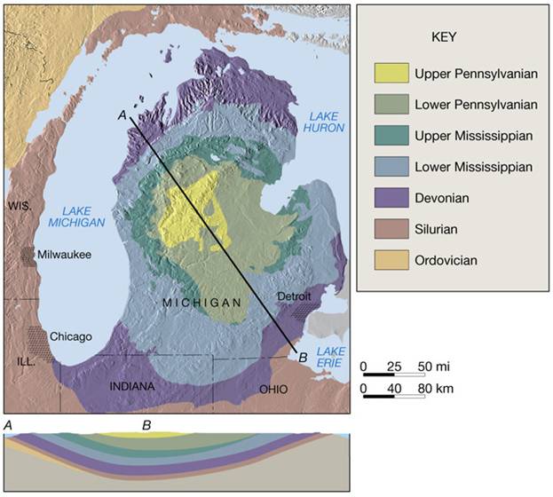
Question 3: Locate several pieces of the orange-brown pieces of the Marshall that are rich with fossils. Sketch or photograph an example of a 1) Nautiloid Cephalopod 2) Pelecypod 3) Ammonite and 4) Crinoid. Please include a scale or measurement with any drawing or photograph. What of the fossils collected above are preserved the best? Why do you think some types of fossils were preserved whole while others are almost always broken? As ancient glaciers developed in southern Gondwanaland, sea levels fell around the world. This depletion of sea water affected the Michigan Basin causing the shoreline or beach to move in closer to what would become the middle portion of our state. Eventually all water evaporated and the remaining salts and dissolved materials precipitated out as additional sediment. If the sand, soil, and gravel that had been deposited during the Pleistocene were to be removed, the bedrock would be exposed and we would be able to see evidence of the Michigan basin shrinking. Please note the ages and the structure of the basin that have been depicted in (Figure 15). A black line that connects points A and B was drawn across the state to illustrate the bowl-shape of the Michigan Basin and that sediments had filled it in over time. The light green color represents the Lower Mississippian that the Marshall Sandstone is part of. Bedrock structures toward the center of our state are younger at the surface in terms of age.
Figure 15:
Bedrock Map and Cross-Section of the Michigan Basin. The second story looks at the journey that these Mississippian-age boulders or fragments had taken during the Pleistocene when Michigan was covered by a continental glacier.
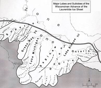
Figure 16:
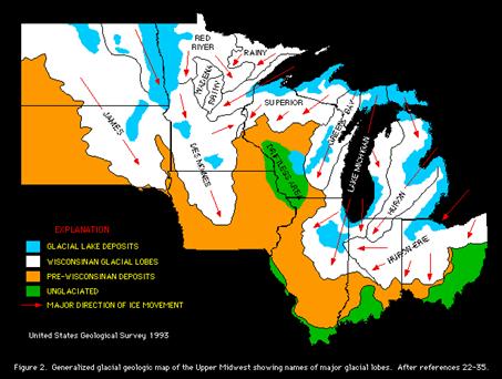
Laurentide Ice Sheet and Associated Ice Lobes During the Wisconsinan Advance, the Laurentide Ice Sheet (Figures 16) consisted of lobes that plucked chunks of bedrock from the Earth and incorporated them into the glacier (Figure 17) as the ice flowed southward into Indiana, Illinois, and Ohio This ice sheet varied in thickness as it slowly moved southward (Figure 18). Scientists estimate that some lobes may have been 10,000 feet thick.
Figure 17: Ice
Plucking of the Local Bedrock
Figure 18:
Glacial Advances and Deposits of the Upper Midwestern United States.
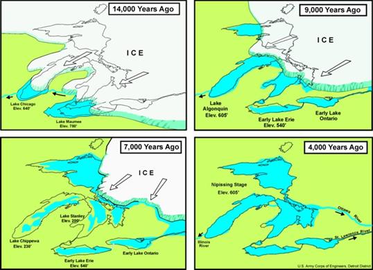
Figure 19: Glacial Retreat 4,000 to 14,000 Years Ago As the ice retreated (Figure 19) 4,000 to 14,000 years ago, vast amounts of glacial till and outwash were deposited onto the land. Some of these sediments make up the Blue Ridge Esker, the kettle lakes and ponds, and the outwash plains that can be seen today within Jackson County, Michigan.
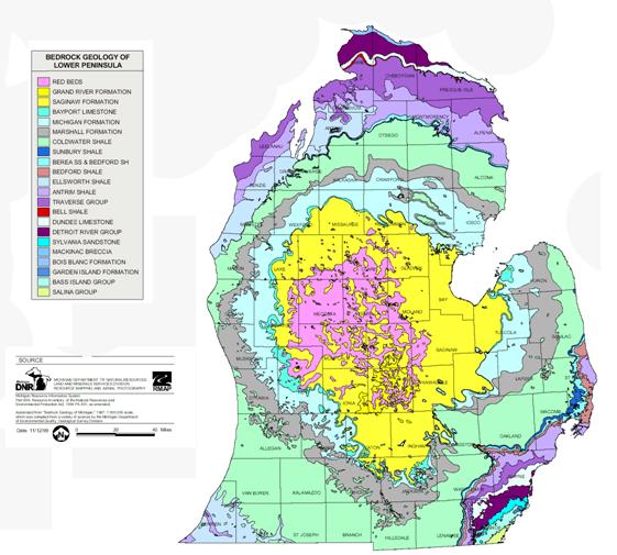
Question 4: Using your knowledge of the Blue Ridge Esker, maps of glacial lobes, bedrock maps, and the relative direction of both ice and water flow, indicate by drawing a narrow rectangle onto a printed copy of the bedrock map of Michigan’s lower peninsula that is shown in Figure 20 where you think the orange-brown sandstone boulders most likely came from prior to being plucked from the bedrock and were later deposited at the Blue Ridge Gravel Pit.
Figure
20: Using this Modified Bedrock Map from
the Michigan Department of Natural Resources, Draw a Rectangle That Shows Where
You Think the Orange-brown Boulders Came From prior to Being Deposited in the
Blue Ridge Gravel Pit.
Question 5: Using your knowledge of the Blue Ridge Esker, the Michigan Basin, maps of glacial lobes, bedrock maps, and the relative direction of both ice and water flow, where do you think the metamorphic and igneous rocks came from that are found in the Blue Ridge Gravel Pit? What is the likelihood that a person might find fossils of animals from the Silurian or Devonian Periods in the Blue Ridge Esker? How could this be explained? Closing Comments: At least two stories of climatic change can be told by
reading the content held within the fossiliferous orange-brown sandstone
boulders and fragments that are easily found at the Blue-Ridge Gravel Pit. These stories and others can be read by
investigating other EarthCache sites that have been designed to help visitors discover
the Big Ideas of Earth Science that explain the natural processes that act upon
our planet. References: Dorr, John A., Donald F. Eschman. Geology of Michigan. University of Michigan Press, 1970. Print. Miller, A.K., H.F Garner. Lower Mississipian Cephalopods of Michigan. Part I. Orthoconic Nautiloids. Museum of Paleontology, The University of Michigan 1953. Print Miller, A.K., H.F. Garner. Lower Mississipian Cephalopods of Michigan. Part II. Coiled Nautiloids. Museum of Paleontology, The University of Michigan 1953 Miller, A.K., H.F. Garner. Lower Mississipian Cephalopods of Michigan. Part III. Ammonoids and Summary. Museum of Paleontology, University of Michigan 1955 Schaetzl, Randall J., Joe T. Darden, and Danita S. Brandt. Michigan Geography and Geology. New York: Custom, 2009. Print. Websites: http://www.geo.mtu/~raman/SilverI/MiTep_ESI-2 Glacial Meltwater http://gemini.oscs.montana.edu/~geol445/hyperglac/meltwater1/index.htm Cephalopods and Ammonites – The Octopus News Magazine Online http://www.tonmo.com/science/fossils/nautiloids.php Earth Science Literacy Principles: http://www.earthscienceliteracy.org/es_literacy_6may10_.pdf Crossbedding http://www.pitt.edu/~cejones/GeoImages/5SedimentaryRocks/SedStructures/CrossBedding1.html Paleogeography http://www.scotese.com/newpage4.htm Paleogeography http://cpgeosystems.com/namM345.jpg 1987 Bedrock Geology of Michigan http://www.michigan.gov/documents/deq/1987_Bedrock_Geology_Map_301466_7.pdf Michigan Quadrangle Maps by County http://www.michigan.gov/dnr/1,1607,7-153-10371_14793-31264--,00.html Images: Figure 1: Continental Glacial Landforms http://academic.evergreen.edu/curricular/energies/Aprojfolder/missoula/Two.htm Figure 2: Glacial Melt-Water Tunnels http://gemini.oscs.montana.edu/~geol445/hyperglac/meltwater1/meltwaterbody_mod.htm Figure 3: Outwash Plain and Continental Glacier http://www.uwsp.edu/geo/faculty/ritter/images/lithosphere/glacial/glacier_Ellesmere_GSC.jpg Figure 4: Clear Lake Esker Map http://webspace.ship.edu/cjwolt/geology/slides/glmap-sum.htm Figure 5: Topographic Map of the Blue Ridge Esker http://www.dnr.state.mi.us/spatialdatalibrary/pdf_maps/topomaps/MICHIGAN_CENTER.pdf Figure 6: Blue Ridge Gravel Pit, Jackson, Michigan Photograph by Reed, Mark S. Figure 7: Cemented Sediments or “Clinker” Photograph by Reed, Mark S Figure 8: Cross-bedding Diagram http://thelifeofyourtime.wordpress.com/2010/08/30/textbook-cross-bedding/ Figure 9: Orange-brown Marshall Sandstone Boulders Photograph by Reed, Mark S. Figure 10: Earth during the Mississippian Period http://www.scotese.com/newpage4.htm Figure 11: The Michigan Basin during the Mississippian http://cpgeosystems.com/namM345.jpg Figure 12: Cartilaginous Fish and Crinoids of the Mississippian Sea http://www.museum.state.il.us/exhibits/changes/htmls/tropical/underwater_mississippian.html Figure 13: Sea Life at a Paleozoic Coral Reef http://www.geology.wisc.edu/homepages/g100s2/public_html/Geologic_Time/L10_Devonian_Life_More.jpg Figure 14: A Fossil Ammonite, Merocanites houghtoni Photograph by Reed, Mark S. Figure 15: Bedrock Map and Cross Section of the Michigan Basin http://hays.outcrop.org/images/lutge8e/Chapter_17/Text_Images/FG17_09.JPG Figure 16: Glacial Lobes of the Laurentide Ice Sheet http://www.geo.msu.edu/geogmich/lobes.html Figure 17: Continental Glacier Plucking Bedrock http://edu.glogster.com/media/4/25/79/12/25791219.jpg Figure 18: Ice lobes and Glacial Advances http://www.radonpro.com/radon_michigan_removal/test_mitigation_maps.shtml Figure 19: Glacial Retreat over Michigan http://www.wetmaap.org/Indiana_Dunes/Supplement/id_background.html Figure 20: Modified Bedrock Map of Lower Michigan http://www.michigan.gov/documents/deq/1987_Bedrock_Geology_Map_301466_7.pdf |
||||||


